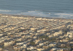
 Ocean County will provide local tax assessors from towns most affected by Hurricane Sandy with before and after aerial images of properties to help in identifying storm damage that is underway.
“These high level resolution images will give local tax assessors a good idea of the extent a property may have been damaged,” said Freeholder John C. Bartlett Jr., who serves as liaison to the Ocean County Board of Taxation. “The comparison of before and after will assist in the task of reassessing properties.”
With funding from the Ocean County Board of Taxation, the Board entered into a contract with Pictometry of Rochester, N.Y. earlier this year in order to provide property data to local tax assessors free of charge.
As part of the contract, Pictometry, during natural disasters agreed to do a flyover of the County.
“The company performed a flyover over the barrier islands and low lying areas east of the Garden State Parkway,” Bartlett said. “Aerial images from the flyover will be made available to towns in order to contrast properties before and after the storm.
“This will be a very good inspection tool for our towns,” he said. “With these images, assessors can see all sides of the structure.” TLS.

